Desolation – Gray Canyons of the Green River
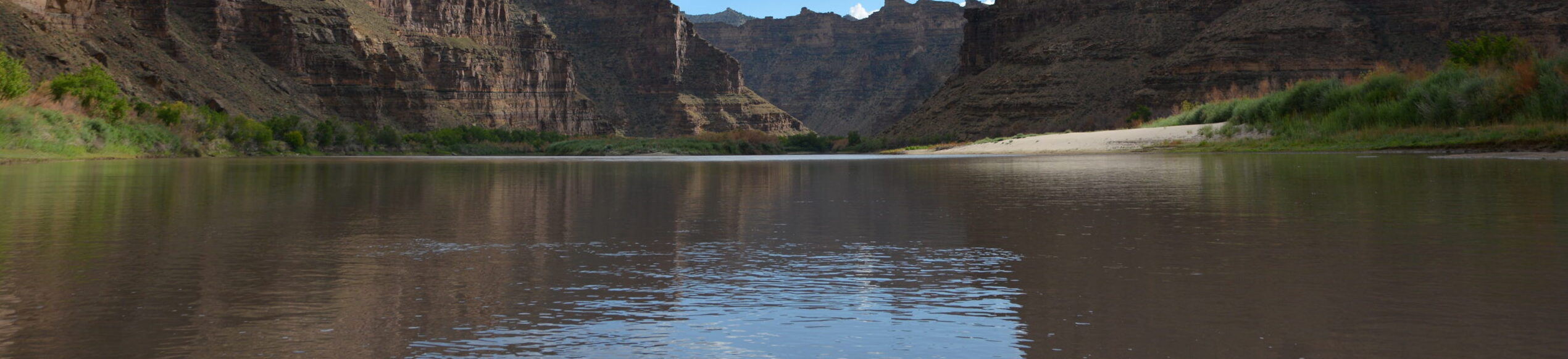
For 84 sinuous miles, the Green River of eastern Utah carves its way through one of the largest roadless areas in the lower 48 states, forming the remote and rugged country of Desolation and Gray canyons as it cuts through the Tavaputs Plateau. Desolation Canyon was so named when, in 1869, John Wesley Powell first chronicled the river’s nearly 60 side canyons, describing the journey as one through “a region of wildest desolation.”
Desolation Canyon
Remote and spectacular, Desolation Canyon has been home to Fremont People, their stories left behind in the pictographs, petroglyphs, and ancient dwellings, towers and granaries that still decorate the canyon’s walls. Since time immemorial, the Desolation Canyon region has also been home to the Ute Indian Tribe, whose Uintah and Ouray Reservation borders the east side of the river from above Sand Wash to Coal Creek Canyon, or 70 miles of Desolation/Gray Canyons.
Now, boaters of all persuasions relish multi-day river trips through relatively easy riffles and rapids, where sandy beaches with massive Fremont cottonwoods provide shade and cover from wind. The piñon, juniper and douglas fir-covered slopes of the canyon harbor wintering deer and elk, nesting waterfowl, bison, mountain lions, migrating birds and the occasional sun-bleached blackbear. Of the 84 river miles, 66 miles are within the Desolation Canyon Wilderness Study Area, the largest WSA in the lower 48 states. Looking up from the river, the edge of the canyon is nearly 5,000 feet overhead , and anywhere from 2-150 million years old. Of the canyon’s unique and exposed geologic history, celebrated southwest writer Ellen Meloy wrote: “You launch in mammals and end up in sharks and oysters.”
DID you know?
There are more than 60 rapids on the Desolation – Gray stretch of the Green River, ranging from class I-III
Edward Abbey floated the Green in November 1980 and described it as “one of the sweetest, brightest, grandest, loneliest of primitive regions still remaining”
In 2019, 63 miles of the Green River (including Labyrinth Canyon and the last 5.3 miles of Deso/Gray) were designated as a Wild & Scenic River in the Emery County Public Land Management Act.
What states does the river cross?
Utah
how can i help?
Our public lands, and by extension our last, best, wild rivers, are under threat.
Tell the Trump Administration to retain and support the Waters of the United States rule under the Clean Water Act. Take action here.
Eat locally – locally grown food cuts down on transportation, reducing our demand for oil and gas, and reduces the need for more drilling on public lands.
Stay informed with what is going on with rivers across the Southwest by following our Southwest River Protection Program. ] and signing up to receive action alerts. Early in 2021, the Comprehensive River Management Plan (CRMP) for the portion of the Green River that was designated as Wild and Scenic in 2019 will begin, and American Rivers will be working with BLM on the effort. We would love your help!
THREATS
While it’s true that Desolation Canyon remains one of the most remote places in the contiguous United States, the threats it faces are not so remote. And ironically, the canyon’s deep and layered history and geology in some ways, threaten the river most. The Green River Formation, formed between 33-56 million years ago, is a much sought after petroleum resource. A recent report by the USGS posited that the formation could hold as much as 1.3 trillion barrels of oil. In order to convert tar sands and oil shale into usable oil (1.55 million barrels/day), producers would require about 378,000 acre feet of water per/year, likely from the Green. While the inner gorge of Desolation Canyon is a designated wilderness study area, on the state, tribal, and federal lands surrounding it, oil rigs march right to the canyon’s edge.
Let's stay in touch!
We’re hard at work in the Southwest for rivers and clean water. Sign up to get the most important news affecting your water and rivers delivered right to your inbox.
The canyon’s existing protections are tenuous at best. In 2019, 142,996 acres were designated as the Desolation Wilderness in the Dingell Act, and 5.3 miles of Desolation-Gray from the Ute Reservation boundary to the take-out were designated under the Wild & Scenic Rivers Act. While this is a good start, 78.6 miles of the river remain lacking permanent protections.
Like so many rivers in the Colorado River Basin, the Green is subject to threats from persistent drought, climate change, and increased consumption from a growing population.
Let’s Stay In Touch Image: Anthracite Creek, Co. | Sinjin Eberle