California Central Valley Program
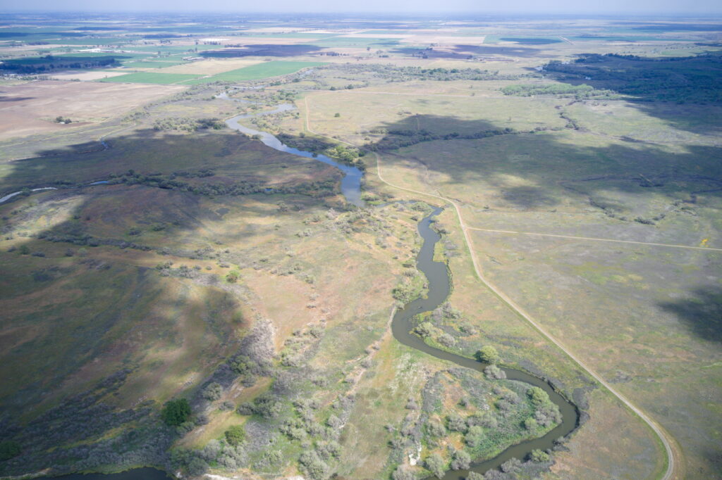
California’s Central Valley is a vital region both ecologically and economically, with the San Joaquin and Sacramento Rivers flowing from their headwaters in the Sierra Nevada to nourish a landscape that stretches from above the Bay Area down to Southern California. With California facing an intense multi-year drought, protecting and restoring these rivers, their wetlands, and tributaries is a cornerstone of American Rivers’ work in California.
The Central Valley program revitalizes waterways and groundwater in the Central Valley by restoring floodplains for multiple benefits, restoring urban waterways, promoting policies and on-the-ground solutions to improve surface water flows, replenishing and protecting groundwater supplies in the river corridor, and increasing access to clean rivers and clean drinking water for all Californians.
Multi-Benefit Floodplains & Restoration
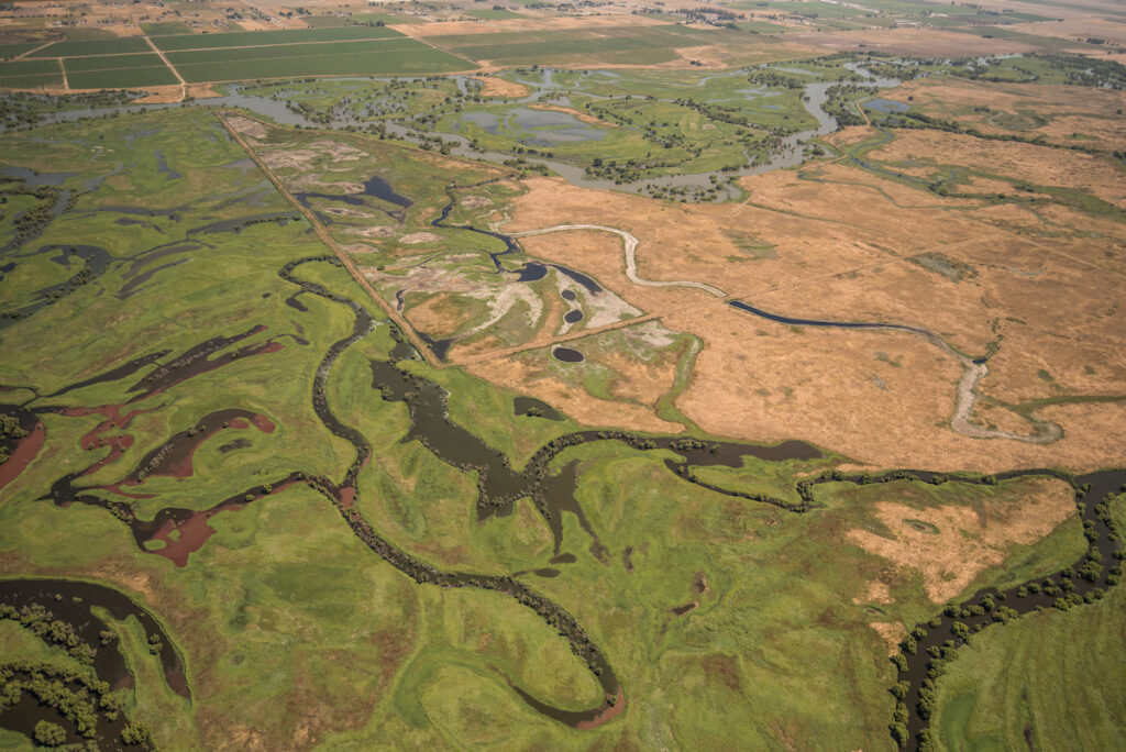
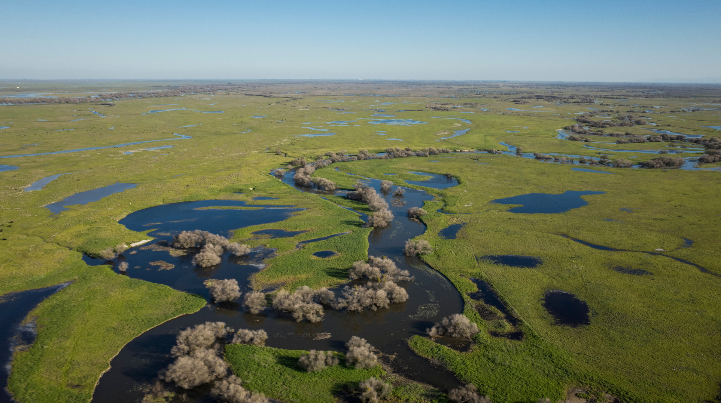
The multi-benefit approach works with nature by managing and/or restoring floodplains to reduce flood risk while providing a range of additional benefits for both humans and wildlife. These benefits include reconnecting natural corridors for wildlife, increasing groundwater storage, improving water quality, reducing downstream flood risk, increasing nature access for all people living in the Central Valley, and building landscape-scale climate resilience. American Rivers has implemented the multi-benefit approach across the Central Valley, creating new opportunities for ecological recovery in a region that has been deeply impacted by development over the last century. Check out specific project pages to get a sense of American Rivers’ work in California and get involved!
Click each image to download full factsheets
Reconnecting Urban Areas
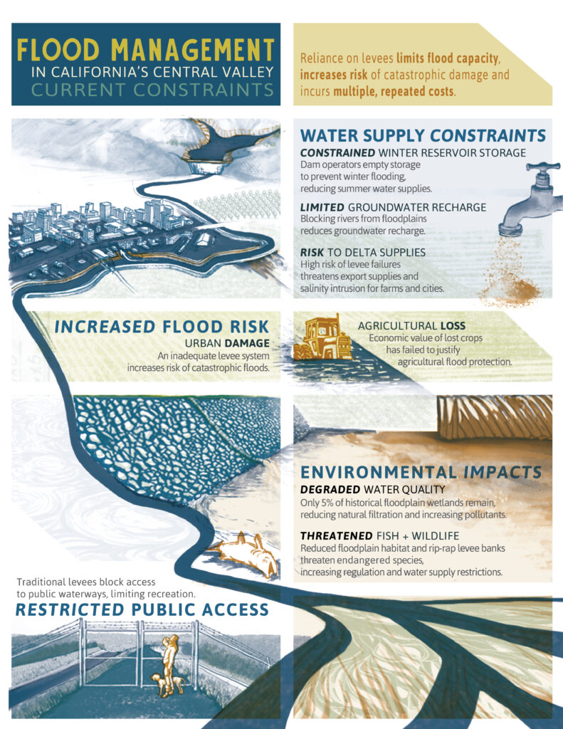
Traditional levees block access to public waterways, limiting recreation in urban communities that might not have easy access to parks and open spaces. Restored rivers create space for parks and trails within the Central Valley’s urban communities. American Rivers builds meaningful partnerships to bring these landscapes to life in urban spaces across California. This work has far-reaching impacts on quality-of-life and helps individuals create connections to the natural world and draw inspiration from restored habitats.
Major Flood Resilience
Inadequate levee systems increase the risk of catastrophic flooding in urban areas, and the economic value of crops lost to flooding has failed to justify traditional methods of agricultural flood protection. Setback levees provide sound solutions for adapting to a warming climate through (a) allowing safer floods and slower floods as more precipitation falls as rain – and not snow—and (b) providing cost-effective farm protection support to productive agriculture as storm intensity increases.

Floods are the most common natural hazard in the United States and are common throughout the Central Valley. Historically, humans have relied on levees to limit flooding. However, this approach limits flood capacity, which increases the risk of catastrophic damage from flooding and incurs multiple, repeated costs from flood recovery and levee maintenance.
Critical Habitat
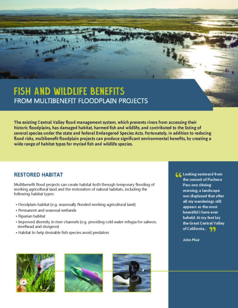
California’s Central Valley is home to a wide range of threatened and endangered species that rely on wetlands ecosystems. But only 5% of California’s historical floodplain wetlands remain, as intensive agricultural and urban land use continues to reduce the natural filtration of pollutants and decrease habitat for wildlife. Restoring natural floodplains restores historical drainage patterns, which filters and cleans water, creates fish and wildlife habitat, and increases wildlife’s resilience to the stresses of climate change.
Current Projects
Great Valley Grasslands – Grasslands Floodplain Restoration Project
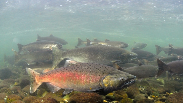
The Grasslands Floodplain Restoration Project is a combined restoration and public access project on the conserved lands of Great Valley Grasslands State Park (GVGSP). GVGSP, located in Merced County in California’s Central Valley, preserves one of the few remaining areas of native grasslands in the Central Valley. This lush stretch of the San Joaquin provides habitat for numerous threatened and endangered species, including fall and spring-run Chinook salmon, as well as the Swainson’s Hawk.
However, the ecological resilience of this 160-acre floodplain site is threatened by poor river-floodplain connectivity, invasive vegetation, and the legacy of damaging land use practices. GVGSP’s historic floodplains have been isolated from the San Joaquin by two levees. Construction of the levees and their associated maintenance have degraded riparian and channel habitats, resulting in higher water temperatures and limited cover for fish species. The Grasslands Floodplain Restoration Project will reconnect the San Joaquin River with historic floodplains in Great Valley Grasslands State Park, San Luis National Wildlife Refuge, and elsewhere to provide multiple benefits, including restoring and protecting habitat and improving ecological function in the Central Valley. The project presents a unique opportunity to improve the functionality and quality of flows in the San Joaquin River, preserve rare grassland species dependent on regular inundation, and restore habitat for salmon and other aquatic species.
The Grasslands Floodplain Restoration Project is a multi-faceted project that improves both the ecological resilience of GVGSP and the well-being of surrounding disadvantaged communities. Currently, no public access exists at this remarkable park. The restoration will enhance access to a walking trail, wildlife viewing, and non-motorized boating, and has the potential to dramatically improve surrounding communities’ ability to access nature and the river. Restoration at GVGSP will also make the river and associated flood system more resilient to climate change, with the floodplain restoration and a widened floodway promising to increase the capacity of the channel to convey floodwaters.
The project is driven by a robust public-private partnership that includes three non-profit organizations (American Rivers, River Partners, Ducks Unlimited), four public agencies (California State Parks, Lower San Joaquin Levee District, U.S. Fish and Wildlife Service, and the Department of Water Resources), and two consulting firms (FlowWest and CH2M).
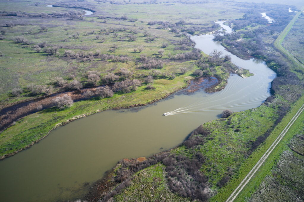
Marsh Creek
Marsh Creek’s headwaters flow down from Mt Diablo, connecting with the Delta at Dutch Slough to provide an important ecological corridor in east Contra Costa County. Over numerous decades, the Watershed has been transformed from a free-flowing creek into a flood control channel that prevents the excessive flooding that inundated the region in the mid-20th century. The creek provides habitat for Fall-Run Chinook salmon that swim upstream to spawn and is also home to the Swainson’s hawk, red-legged frogs, turtles, Steelhead, snowy egrets, numerous species of riparian songbirds, and river otters. American Rivers is spearheading two restoration projects along the Marsh Creek watershed at Three Creeks and Creekside Park in Oakley.
At Three Creeks, American Rivers is implementing a multi-benefit project designed to improve water quality, filter stormwater filtration, reduce flood risk, and restore native vegetation along a 4,000 linear foot section of Marsh Creek as well as on 12.5 acres of adjacent land. This project will reestablish the thriving native vegetation and functional floodplains that will slow and filter polluted runoff in Marsh Creek. American Rivers has partnered with the Contra Costa County Flood Control District to transform this stretch of the Watershed and is working alongside community partner organizations such as the Friends of Marsh Creek Watershed and the Watershed Council of Marsh Creek to revitalize natural space and expand accessibility for residents of Contra Costa County.
In the city of Oakley at Creekside Park American Rivers has been working in partnership with East Bay Regional Park District, the Contra Costa County Flood Control District, East Contra Costa County Habitat Conservancy, and the city of Oakley to increase the restored riparian area and floodplains along Marsh Creek through a multi-benefit restoration that is bringing over 700 linear feet of the creek back to life on 2.4 acres of land. This project provides habitat for native fish and wildlife, improves water quality, increases resiliency to a changing climate, and enhances the experience of those hiking along the Marsh Creek Trail. This project also aims to improve the quality of life for Delta residents in one of the most densely developed areas of the region by reducing flood risk, improving recreational opportunities, and providing a place to make meaningful connections with the natural world of the Delta region.
Policy Work
American Rivers supports and advocates for state and federal policy measures that address the intertwined issues of biodiversity loss, racial injustice, and the accelerating impacts of climate change in California’s Central Valley. Whether a policy has an impact on fish migration or other river-dependent wildlife species to keep species healthy and thriving, an impact on groundwater recharge in the historic floodplain, or on flood risk mitigation to keep communities safe, we are committed to forward-thinking legislation that benefits communities, ecosystems, and the wildlife that depend on them. We participate alongside other environmental advocacy organizations, agencies, and other stakeholders to create action and impact in the state legislature and within the agencies that govern the natural resources and environment of California.
Reconnecting floodplains
Central Valley Flood Protection Plan (CVFPP)
The Central Valley Flood Protection Plan (CVFPP) is a key document outlining California’s strategic effort to assess and mitigate flood risk in California’s Central Valley. The CVFPP guides the State’s participation in managing flood risk in areas protected by the State Plan of Flood Control (SPFC) in the Central Valley. The CVFPP is updated every 5 years and works to prioritize the State’s investment in flood management looking 30 years into the future, integrating multi-benefit projects that improve ecosystem functions in areas of high flood risk. With the impacts of climate change already echoing through the Central Valley, flood risk remains a high priority, with about 1.3 million Californians working in the floodplains of the Central Valley. The CVFPP and its priorities have both regional and national relevance because of the potential impacts of flooding in the Central Valley to residents and structures, and to the national economy and national food security.
American Rivers is committed to participating in the process of flood risk management in the Central Valley, directly impacting flood resilience through our multi-benefit restoration work on the ground and providing policy recommendations and the support of our expertise to state agencies. We believe environmental advocacy groups and communities should be able to voice their concerns and impact the trajectory of state policy, and through established communities of practice, we strive to ensure inclusion and fairness in policymaking to mitigate flood risk while simultaneously ensuring the resilience of the natural world.
State of California Plan of Flood Control
The State Plan of Flood Control (SPFC) system is the largest flood control system in California and includes flood control projects that incorporate state and federally controlled facilities in California’s Central Valley. Within the Sacramento and San Joaquin Hydrologic Regions there are many reservoirs, channels, levees, bypasses, and related facilities that reduce the threat of major flooding in urban and rural areas along the Sacramento and San Joaquin rivers and their tributaries. The SPFC system protects about 1.7 million acres and, critically, SPFC facilities protect more than 1 million people and $70bn in assets. A portion of this extensive flood protection system includes State and federally authorized projects for which the Central Valley Flood Protection Board or DWR has provided assurances of cooperation to the federal government. These assurances constitute the SPFC. In 2006 and 2007, California voters approved the Disaster Preparedness and Flood Prevention Bond Act of 2006 and the Central Valley Flood Protection Act of 2008. These acts defined the Sacramento River and San Joaquin River federal-State flood control projects as the SPFC. Updates to the SPFC Descriptive Document occur periodically. American Rivers supports updates to the SPFC Descriptive Document that further the aims of restoration and that emphasize natural, multi-benefit solutions that mitigate flood risk for communities, enhance ecosystem functions, and promote climate resilience. Some of American Rivers’ current projects in the Central Valley address the concerns that led to the creation of the SPFC, such as the multi-benefit floodplain restoration occurring at Great Valley Grasslands State Park.
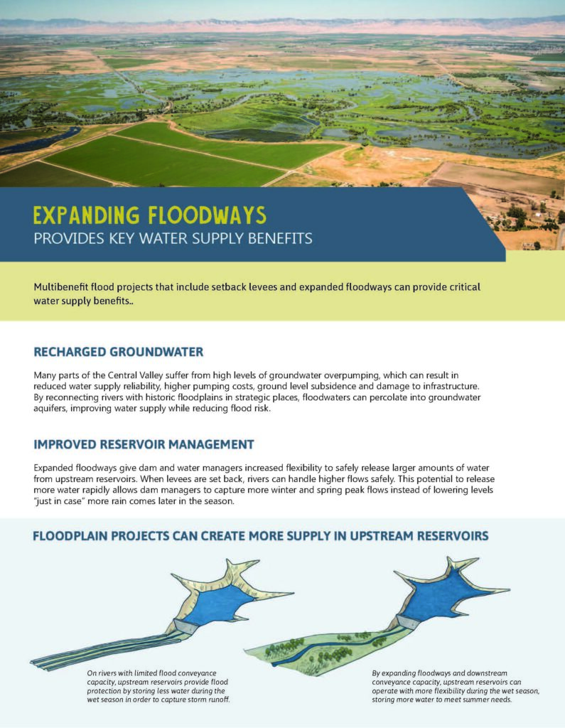
Flood Managed Aquifer Recharge (Flood-MAR)
Flood-MAR is a resource management strategy that focuses on using the natural flood patterns of rivers to recharge groundwater in the Central Valley’s floodplains. Rather than building resource-intensive concrete channels to divert flows, Flood-MAR strategies use existing natural features to convey water back onto the historic floodplain, providing multiple benefits to fish, wildlife, and communities. Flood-MAR speaks to a higher level of organization in a watershed, coordinating flood operations and reservoir operations with strategic releases of floodwaters across river-adjacent agricultural lands. With shifting precipitation patterns coming with a changing climate (high-volume events followed by periods of extensive drought), Flood-MAR strategies focused on the natural historic floodplain are a crucial means of capitalizing on natural features without investing in further infrastructure. This is a new area of policy engagement for American Rivers. In California’s Central Valley, American Rivers designs and implements projects that employ river-adjacent Flood-MAR strategies to enhance groundwater recharge such as our work at Great Valley Grasslands State Park and River Garden Farms.