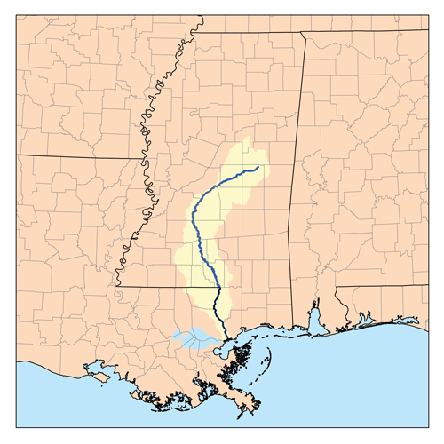
Pearl River

The Pearl River ranks 4th in freshwater discharge among the rivers draining into the Gulf. This river provides drinking water to hundreds of thousands of residents in Metropolitan Jackson, Mississippi. In addition, estuaries in Louisiana and Mississippi at the Pearl’s mouth are highly influenced by the river’s freshwater flows. Productive oyster reefs in the Mississippi Sound and in Louisiana’s Biloxi marshes need the salinity moderation the river provides. The marshes and oyster reefs in these areas took a direct hit from Hurricane Katrina in 2005, sustaining considerable damage that was later compounded by the Deepwater Horizon oil spill in 2010. Oyster reef restoration projects near the mouth of the Pearl River are ongoing in both states.
The Pearl River is home to 110 species, including two federally-threatened species (Gulf sturgeon and the endemic ringed sawback turtle) and other species of special concern (pearl darter and frecklebelly madtom). This project would also impact floodplain forest bottomlands along the Pearl River in Jackson, including part of LeFleur’s Bluff State Park, which is designated as an Important Bird Area by Audubon Mississippi.
Threats to This River
The Pearl River is threatened by a new dam that would create another impoundment on its main channel. The Ross Barnett Dam, built in 1963, created a 32,000 acre reservoir for drinking water and recreation north of Jackson, Mississippi. Operation of that dam has changed downstream reaches in two ways. First, banks are unstable, often collapse, and contribute more sediment than the lower river can move efficiently. Second, dam operation coupled with evaporation effects cause water deficits downstream in Louisiana’s Honey Island Swamp and at the coast. Furthermore, water releases at the Barnett Dam during storms or hurricanes have, at times, contributed to coastal storm surges, exacerbating flooding along the lower Pearl River. Sea level rise on the coast, coupled with low flows, already cause saltwater intrusion in the lower basin’s cypress swamps. Climate change will magnify these impacts.
What states does the river cross?
Louisiana, Mississippi
This year, the Rankin-Hinds Pearl River Flood and Drainage Control District is sponsoring an Environmental Impact Statement (EIS) and feasibility study for a new dam, impounding a new reservoir 9 miles downstream of the existing Barnett Dam. This proposed artificial lake is a dredging project to widen, deepen, and straighten 7 miles of the river and place a low-head dam or weir at the downstream end. This project is being advertised as a flood control strategy to decrease flood elevation in urban Jackson. While the flood control features of this lake design are unproven, areas immediately downstream of this new dam will likely feel the negative effects of faster flows and riverside habitat in a state park will be submerged. Ultimately, levees will need to be improved, and more bank collapse, sedimentation, erosion, and rapid evaporation are certain to follow. Further changes to the amount and timing of freshwater discharge threaten coastal fisheries, especially the oyster industry. The Pearl River needs comprehensive restoration and natural flood protection strategies, not more outdated dam projects.
Let's stay in touch!
We’re hard at work in the Central Region for rivers and clean water. Sign up to get the most important news affecting your water and rivers delivered right to your inbox.
One Louisiana Parish and the Mississippi Commission on Marine Resources have passed resolutions in opposition to the project. Additionally, the Louisiana Coastal Protection and Restoration Agency and the Louisiana Wildlife and Fisheries Department are both on record outlining serious concerns about the project.